Breaking News
Capstone Student Projects Tackle Water and Climate Challenges in Environmental Justice Communities
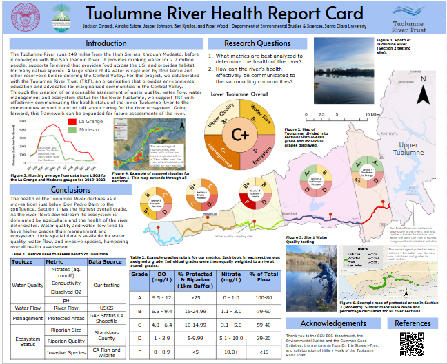
Photo Caption: Data collection and GIS mapping found that the Tuolumne River is depleted and contaminated by the time it reaches the Central Valley
Three amazing student teams and their partners tackled some important water and climate justice questions. The projects were:
(1) Tracing the River’s Story: Mapping Decades of Riparian Habitat Loss Along the Salinas River
Birana Guingona, Ava Pape, Luke Davidson and Sophia Harvey worked with Chelsea Tu and Natalie Herendeen at Monterey Waterkeeper at the Central Coast.
This study maps the changes in riparian habitats along the Salinas River over time, focusing on the study areas of King City and South Salinas. Riparian habitats, though comprising only 0.8% to 2% of the landscape in the western United States, are ecologically critical, supporting over half of the region’s wildlife species and providing essential resources such as water and habitat. However, these habitats face significant threats from agricultural expansion, urbanization, and land use changes. This study addresses three key research questions: (1) How has the extent of riparian areas along the Salinas River changed over time? (2) How can aerial photography and remotely sensed data sets be leveraged to monitor these changes? and (3) Which areas along the Salinas River are most in need of conservation efforts? Using digitized aerial photography and remotely sensed data, the analysis reveals a clear decline in riparian habitat over the past few decades, with the most pronounced losses occurring in recent decades—32.6% in King City (1994–2002) and 30.6% in South Salinas (1984–1998). Both methods provide effective visual representations of these changes, but they are limited by data availability, differing temporal and spatial resolutions, and subjective interpretations and reclassification decisions. Furthermore, the primary driver of riparian habitat loss in both study areas is agricultural expansion. Increased agricultural land use reduces river flow due to higher water extraction for irrigation, while the use of fertilizers and pesticides further degrades water quality and habitat biodiversity. These findings underscore the need for targeted conservation efforts to mitigate further loss. Recommendations include reinforcing riparian boundaries, extending existing habitats to enhance ecological functionality, and fostering collaboration among stakeholders—such as conservation organizations, local governments, and agricultural industries—to establish consistent definitions and management practices.
---------------------------------------------------------
(2) A Tuolumne Health Report Card
Ben Kyrillos, Amalia Eulate, Jackson Giraudi, Jasper Johnson, Piper Wood worked with Hilary Beardsley at the Tuolumne River Trust.
The Tuolumne River supports a dwindling population of native Chinook Salmon, irrigates over 200,000 acres of farmland in Stanislaus County, and provides drinking water for 2.7 million people in the Bay Area. The river is of great importance for the community of humans, plants, and animals that it supports. Given this river's importance, an assessment of its health is vital, to understand which aspects stand to be improved. In partnership with the Tuolumne River Trust, the team developed a framework to conduct an assessment of the river’s health. The focus of this study was on the lower portion of the river, as it flows from Don Pedro Dam through Modesto, where it is flanked by historically marginalized communities. This focus area was then split into five sections based on urban development and agriculture patterns. Each metric used to assess the river was graded, A-F, via rubrics created from appropriate literature and environmental thresholds. A mix of existing data and data collected by this study were then graded. The study found that the healthiest portion of the Lower Tuolumne is just below Don Pedro Dam. As the river flows downstream into areas dominated by agriculture and urban development, where marginalized communities live, this health declines. The final stretch of the Tuolumne sees improvement in overall health, likely the result of an increased percentage in protected areas, such as Dos Rios State Park, that manage this stretch of the river.
---------------------------------------------------------
(3) The Ethical Dimensions of the 2023 Pajaro Valley Levee Failure
Jessica Garofalo and Arden DiCicco worked on this project with engineering students Mahi Shah and Hannah Hamawi and faculty co-mentors David DeCosse (Markkula Center for Applied Ethics) and Rocio Lillen Segura (Civil, Environmental and Sustainable Engineering.
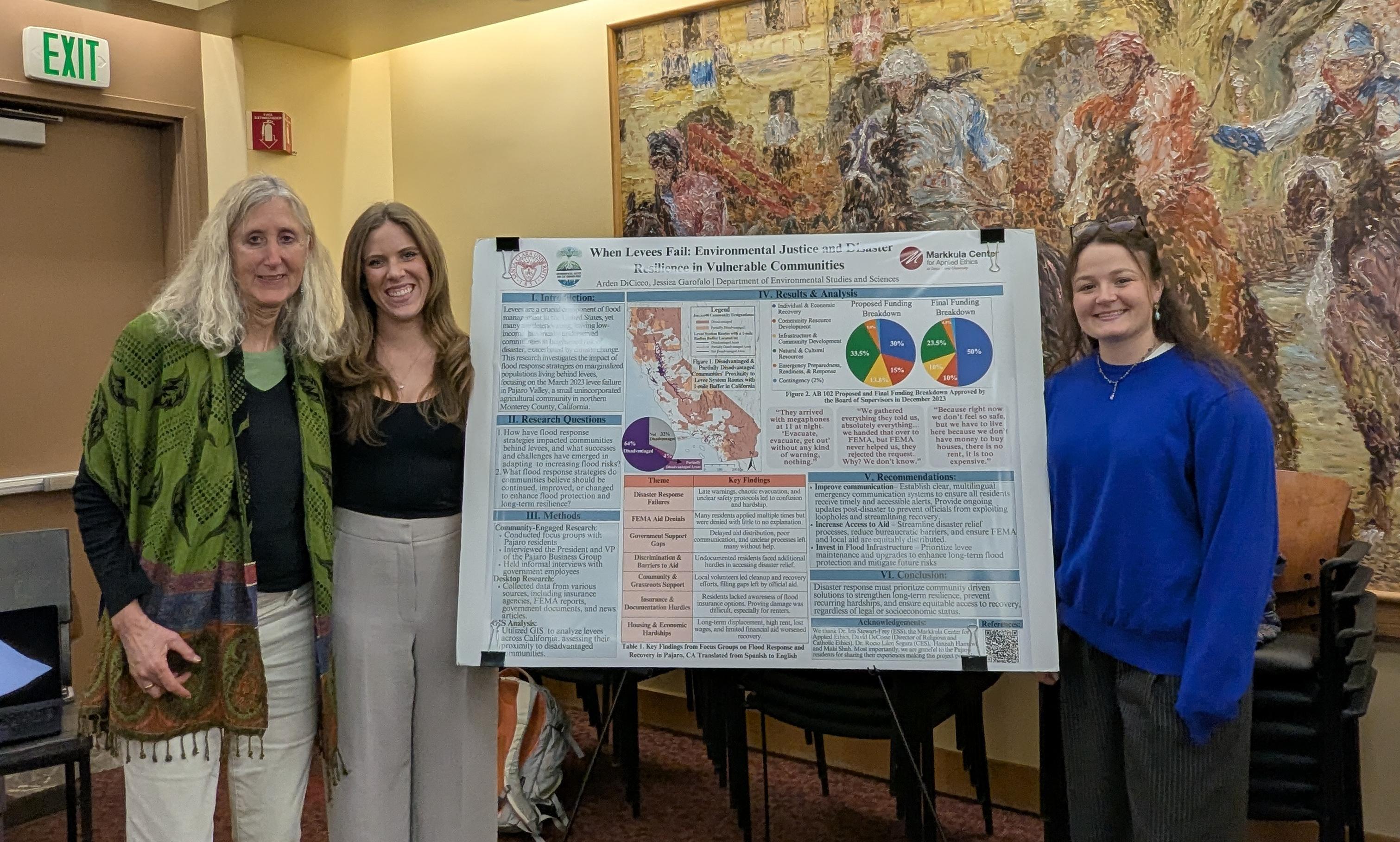
This project explores the ethical implications and socio-political context of the March 10, 2023, flooding in Pajaro, an unincorporated community in Monterey County, California. Historically marginalized communities like Pajaro face an unequal burden of climate-related hazards, exacerbated by insufficient infrastructure and systemic inequities. Addressing these challenges is essential for safeguarding vulnerable communities and advancing environmental justice. Using a mixed-methods approach—including semi-structured interviews and spatial analysis with Pajaro residents and community leaders—the research project aimed to inform more equitable interventions and foster sustainable recovery efforts that protect all residents, regardless of socioeconomic status.
Findings indicated that the 2023 Pajaro levee failure was not just an infrastructure failure—it was a failure of governance, planning, and social responsibility. This disaster disproportionately impacted vulnerable, unincorporated communities, as government agencies, while acknowledging aging levees as a risk, delayed action, thus forcing marginalized communities to bear the consequences of recurring climate disasters. A key takeaway is the indispensable role of grassroots organizations in disaster response and recovery. These groups provide essential resources, fill gaps left by delayed government aid, and help rebuild trust through advocacy and community mobilization. Strengthening their role in disaster planning and policy discussions is essential for a more just and resilient future.